Reachable Areas |
Learn more about Verizon Connect GeoBase.
Get information about the latest release
A Reachable area is a polygonal region (like a GeoFence) that can be reached from a specified location within a maximum amount of time or distance. To define a reachable area, you need to indicate:
- The location where you are starting from.
- The strategy you want to take when reaching another location within the reachable area. This can be by taking the shortest driving route, the fastest driving route, or by walking.
- The maximum time or distance you have to reach a destination within the reachable area.
- Whether you want to define a concave or convex area.
This topic will show you how to display reachable areas on the map.
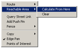
Defining reachable areas starts with the location you are travelling from. Right click a point on the map and select Reachable Area | Calculate From Here.
A dialog appears where you can specify the routing strategy to use for traveling from your starting point to any destination within the reachable area and the limits that define the extent of the reachable area.
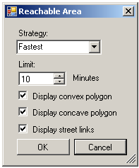
First, select a routing strategy. This is the strategy that determines how a route is chosen from the starting point to a destination within the reachable area. You can choose:
- Shortest - This strategy chooses the route with the shortest driving distance.
- Fastest - This strategy chooses the route with the shortest driving time.
- Pedestrian - This strategy chooses the best route for someone walking. It assumes an average walking speed of 3 mph (5 kph).
When you have selected a strategy, select the maximum distance or time that can be traveled to a destination within the reachable area. When the strategy is "Shortest", you can specify the maximum distance; when the strategy is "Fastest" or "Pedestrian", you can specify the maximum time.
Finally, specify how you want to see the reachable area displayed. You can specify any or all of:
- A convex polygon. This is the polygon formed by connecting all the farthest points that can be reached.
- A concave polygon. This is the smallest polygon that contains all the reachable points.
- All street links. This is just the street links that can be reached.
When you click "OK", the reachable areas are displayed on the map:
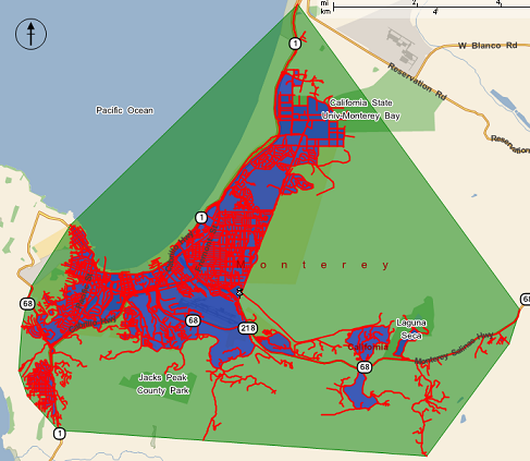
The screenshot above shows the reachable area in all three ways. The convex polygon is shown in green. The concave reachable area is shown in blue. The actual street links that can be reached are all shown in red.
For more information on Reachable Areas, take a look at the following topics and reference material: