Data File Regions |
Learn more about Verizon Connect GeoBase.
Get information about the latest release
Map data for large countries may be split into smaller regions. This split may be made for either of the following reasons:
Legacy Platform Support - to retain compatibility with FAT32 filesystems, GBFS files cannot exceed 4 gigabytes in size. If a country contains too much information to fit within this limit, it will be split into two smaller files.
Reduced Storage Requirements - For platforms where storage is limited, deploying a smaller GBFS file containing only local data can be more efficient.
Currently, we offer the United States in two different GBFS sets; USA East/USA West, for full USA coverage, and USA Regions, for storage-space efficient deployment in specific geographic areas.
If you are using the US map data files for 17Q2 (second quarter of 2017) or 17Q3 (third quarter of 2017) to create the full USA map, note the following:
The following GBFS files and data versions require a GeoBase version of 4.39 or later:
|
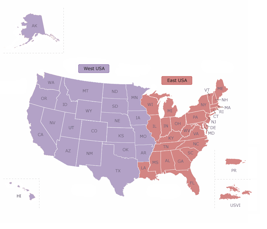
These two GBFS files are designed to be used together in a single repository to provide full USA coverage. This is ideal for deployments where storage space is not restricted, such as desktop or server deployment.
| Dataset Name | States/Territories |
| USAWest | Alaska, Washington, Oregon, California, Hawaii, Montana, Idaho, Wyoming, Nevada, Utah, Colorado, Arizona, New Mexico, North & South Dakota, Nebraska, Kansas, Oklahoma, Minnesota, Iowa, Missouri, Arkansas, Texas. |
| USAEast | Wisconsin, Illinois, Michigan, Indiana, Ohio, Louisiana, Kentucky, Tennessee, Mississippi, Alabama, West Virginia, Maryland, Delaware, District of Columbia, Virginia, North & South Carolina, Georgia, Florida, Maine, New Hampshire, Vermont, Massachusetts, Connecticut, Rhode Island, New York, New Jersey, Pennsylvania, Puerto Rico, US Virgin Islands |
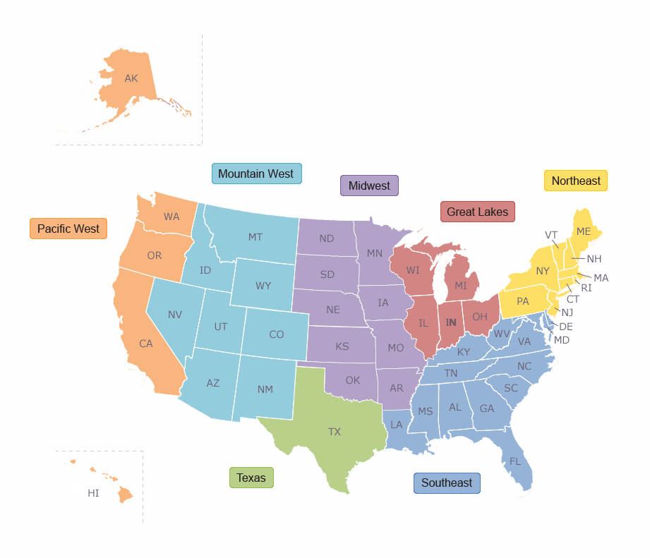
These GBFS files are designed for deployment individually, to provide local geographical coverage in environments where storage space is at a premium. If you require full USA coverage, we recommend using the West USA/East USA GBFS files.
| Dataset Name | States/Territories |
| PacWest | Alaska, Washington, Oregon, California, Hawaii |
| MountainWest | Montana, Idaho, Wyoming, Nevada, Utah, Colorado, Arizona, New Mexico |
| MidWest | North & South Dakota, Nebraska, Kansas, Oklahoma, Minnesota, Iowa, Missouri, Arkansas |
| Texas | Texas |
| GreatLakes | Wisconsin, Illinois, Michigan, Indiana, Ohio |
| SouthEast | Louisiana, Kentucky, Tennessee, Mississippi, Alabama, West Virginia, Maryland, Delaware, District of Columbia, Virginia, North & South Carolina, Georgia, Florida |
| NorthEast | Maine, New Hampshire, Vermont, Massachusetts, Connecticut, Rhode Island, New York, New Jersey, Pennsylvania |
| Territories | Puerto Rico, US Virgin Islands |
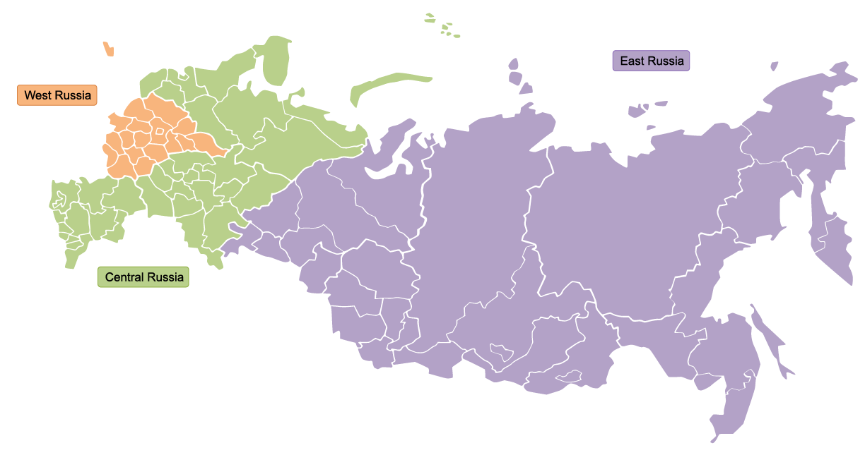
These three GBFS files are designed to be used together in a single repository to provide full coverage of Russia. This is ideal for deployments where storage space is not restricted, such as desktop or server deployment.
| Dataset Name | Regions |
| WestRussia | Tsentral'niy, Kaliningrad |
| CentralRussia | Severo-Zapadny, Privolzhskiy, Yuzhniy, Severo-Kavkazskiy |
| EastRussia | Ural'skiy, Sibirskiy, Dal'nevostochniy |
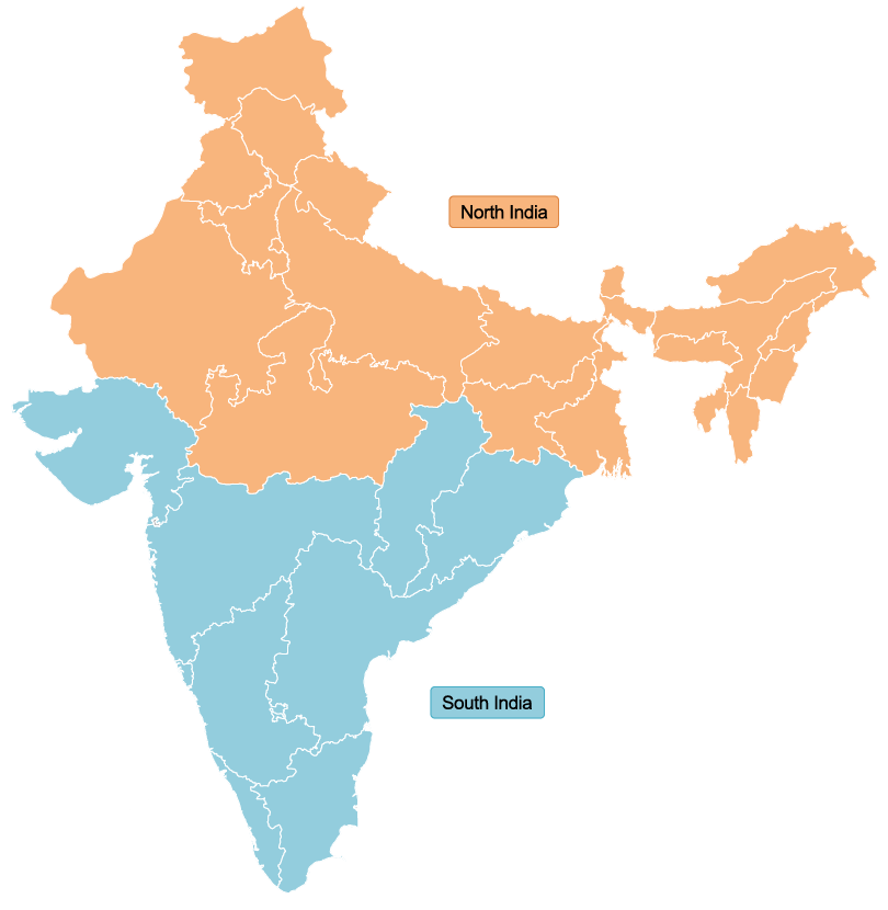
These two GBFS files are designed to be used together in a single repository to provide full coverage of India. This is ideal for deployments where storage space is not restricted, such as desktop or server deployment.
| Dataset Name | Regions |
| NorthIndia | Arunachal Pradesh, Assam, Bihar, Chandigarh, Delhi, Haryana, Himachal Pradesh, Jalpaiguri, Jammu & Kashmir, Jharkhand, Madhya Pradesh, Manipur, Meghalaya, Mizoram, Nagaland, Punjab, Rajasthan, Sikkim, Tripura, Uttar Pradesh, Uttarakhand, West Bengal |
| SouthIndia | Andaman & Nicobar Islands, Andhra Pradesh, Chhattisgarh, Goa, Gujarat, Lakshadweep, Karnataka, Kerala, Maharashtra, Odisha, Puducherry, Tamil Nadu, Talangana |
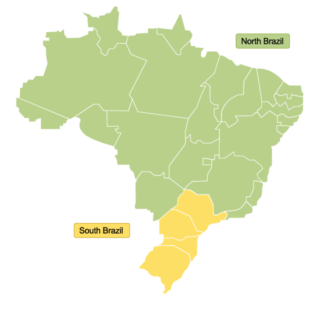
These two GBFS files are designed to be used together in a single repository to provide full coverage of Brazil. This is ideal for deployments where storage space is not restricted, such as desktop or server deployment.
| Dataset Name | Regions |
| NorthBrazil | Acre, Alagoas, Amapá, Amazonas, Bahia, Ceará, Distrito Federal, Espirito Santo, Goiás, Maranhão, Mato Grosso, Mato Grosso do Sul, Minas Gerais, Pará, Paraíba, Pernambuco, Piauí, Rio de Janeiro, Rio Grande de Norte, Rondônia, Roraima, Sergipe, Tocantins |
| SouthBrazil | Paraná, Rio Grande do Sul, Santa Catarina, São Paulo |