Column |
Learn more about Verizon Connect GeoBase.
Get information about the latest release
Shapefiles contain GIS data in a tabulated form. Each GIS data table contains a number of attributes that are organized into table columns.
Shapefile .dbf files may often be opened with a spreadsheet package to examine the columns (attributes) contained within the data set. |
Column names are denoted by a leading percent sign (%) followed by a letter. This instructs Alchemy to reference the data from column in a specified shapefile. The remainder of the name may be made up of any combination of letters, numbers and underscores. The name may optionally end with a question mark (?) which indicates that some cells in the named column may contain null values.
Alchemy uses a special column (identified by %geom) to represent the geometry of a feature. |
By examining the sample waterbody.dbf shapefile (found in the \tools\Alchemy\samples\allegheny directory) using a spreadsheet package, we see that there are 7 columns: ID, AREA, and so on.
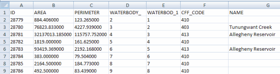
To reference the NAME and PERIMETER attributes (from the respective columns) we use the names %name and %perimeter. Note that column names are case insensitive.