IMPORT STREETS Statement |
Learn more about Verizon Connect GeoBase.
Get information about the latest release
This statement converts GIS-formatted street data to GBFS data.
Several IMPORT STREETS statements can be used in succession, but a COMMIT statement must be made before the destination table is updated. If you're importing turn restrictions (using the IMPORT CONSTRAINTS statement) ensure that all restrictions relevant to the streets in this IMPORT STREETS statement have been imported before you COMMIT the street data, otherwise the IMPORT CONSTRAINTS statement will fail. |
For streets with more than one name, these available names will be sorted in the following order:
Note, however, that some older GBFS files may be sorted alphabetically in step four. |
Syntax
IMPORT STREETS [id = %id_col, gbfs1 = %col1] FROM "path\src_file" WHERE condition;
Nomenclature
| id_col | A column of unique Link ID identifiers in the source table. Note that Link ID values of 0 and 1 are reserved and cannot be imported. |
| gbfsX | One or more GBFS columns. See the 'Columns' section below for a list of appropriate GBFS columns. |
| colX | An expression referencing one or more GIS columns in src_table. This column will be converted to GBFS data. |
| path\src_file | Specifies the path and file containing the GIS shapefile data. |
| condition | A logic expression that is satisfied by a subset of the data in path\src_file. This expression, along with the WHERE keyword, is optional. |
Example
By opening the sample 'travel_route.dbf' shapefile (found in the 'GeoBase Examples\Alchemy\Allegheny' folder) using a spreadsheet package, we see something similar to the following: (Note that a number of columns and rows have been hidden).
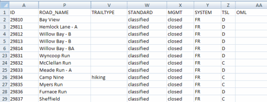
We will use the IMPORT STREETS command to import this data. The 'ID' column (above) provides a unique ID for each road, and we will use the 'ROAD_NAME' column as the name. We will conditionally mark roads as suitable for vehicles using the ar_auto flag (see 'Columns' section, below) - if the 'TRAILTYPE' is 'hiking' we set ar_auto to false otherwise ar_auto is true. We will mark all roads as accessible to pedestrians (using the ar_pedest flag).
IMPORT STREETS [
  id = %ID,
  name = %ROAD_NAME,
  ar_auto = not string.contains(%TRAILTYPE, "hiking"),
  ar_pedest = true
] FROM "travel_route";
IMPORT STREETS with CSV Files
To import streets or polygons from CSV format text files, use the following format.
IMPORT STREETS [id = %no, name = %name, geom = wkt(%wkt)] FROM "csv://src_file";
Nomenclature
| id | A column of unique Link ID identifiers in the CSV source file. Note that Link ID values of 0 and 1 are reserved and cannot be imported. |
| name | An expression referencing one or more column in the CSV source file. |
| geom | A column of shape data stored as well known text (WKT) in the CSV source file. |
Example
id,road_name,wkt_data
1,North Road,"LINESTRING(-32.16641096 18.80887248,-32.16641096 18.80887248,-32.16916157 18.81348722,
-32.16846419 18.81283813,-32.16789691 18.81174513,-32.16754688 18.81020822,-32.16714052 18.80891003,
-32.16652898 18.80870484,-32.16565726 18.80856805,-32.16475604 18.80860292,-32.16399966 18.80891003,
-32.16350479 18.80955913,-32.16321377 18.81017335,-32.16272024 18.81130122,-32.16208054 18.81225743,
-32.16085879 18.81246262,-32.15994952 18.8119141,-32.15931116 18.80993329,-32.15884579 18.80771242,
-32.15875862 18.80528771,-32.15884579 18.80303331,-32.15893162 18.80043827,-32.15893162 18.79811548)"
The IMPORT STREETS statement required to import data from the example CSV file shown above is:
IMPORT STREETS [
  id = %id,
  name = %road_name,
  geom = wkt(%wkt_data)
] FROM "csv://mycsvfile.csv";
The 'id' column provides a unique ID for each road, and we will use the 'road_name' column as the name. The 'wkt_data' column provides street polygons stored as LineStrings or MultiLineStrings.
Import files should include either streets or polygons, not both, within the same file. |
Geometry data stored in the CSV file should be contained within quotes, unless data is separated by pipes (|); for example:
id|road_name|wkt_data
1|North Road|LINESTRING(-32.16641096 18.80887248,-32.16641096 18.80887248,-32.16916157 18.81348722,-32.16846419 18.81283813,-32.16789691 18.81174513,-32.16754688 18.81020822,-32.16714052 18.80891003,-32.16652898 18.80870484,-32.16565726 18.80856805,-32.16475604 18.80860292,-32.16399966 18.80891003,-32.16350479 18.80955913,-32.16321377 18.81017335,-32.16272024 18.81130122,-32.16208054 18.81225743,-32.16085879 18.81246262,-32.15994952 18.8119141,-32.15931116 18.80993329,-32.15884579 18.80771242,-32.15875862 18.80528771,-32.15884579 18.80303331,-32.15893162 18.80043827,-32.15893162 18.79811548)
Note that the import script must include an appropriate suffix to indicate the field separator if using pipes. See the Alchemy Input Files section for more details. For pipes, this suffix should be ^P. For example:
IMPORT STREETS [
  id = %id,
  name = %road_name,
  geom = wkt(%wkt_data)
] FROM "csv://mycsvfile.csv^P";
Column Names
Street Orientation: Left, Right, Reference- and Non-Reference-Nodes In order to aid location finding and route mapping, each street segment or "link" has one of its ends designated as the "reference node"; similarly, the opposite end is the "non-reference node". Accordingly, the left and right sides of a link are defined for an observer standing at the reference node, facing towards the non-reference node. These definitions affect columns such as RPOSTCODE, LADDRSCH and RNREFADDR, among others. |
The following GBFS columns are available for population through the Alchemy IMPORT STREETS statement.
To see which columns are required for certain types of functionality refer to the Functionality and Column Usage topic. |
Column | Description | Type | Length | Values | Used For |
AR_AUTO | Automobile access. | Boolean | 1 | Y: allowed N: not allowed | Navigation Routing |
AR_BUS | Bus access. | Boolean | 1 | Y: allowed N: not allowed | Navigation Routing |
AR_CARPOOL | Carpool access. | Boolean | 1 | Y: allowed N: not allowed | Navigation Routing |
AR_DELIV | Delivery access. | Boolean | 1 | Y: allowed N: not allowed | Navigation Routing |
AR_EMERVEH | Emergency vehicle access. | Boolean | 1 | Y: allowed N: not allowed | Routing |
AR_PEDEST | Pedestrian access. | Boolean | 1 | Y: allowed N: not allowed | Routing |
AR_TAXIS | Taxi access. | Boolean | 1 | Y: allowed N: not allowed | Routing |
AR_TRAFF | Automobile through traffic access. Public streets with posted or legal restrictions such as "No Through Traffic" or "Residents Only", links that are internal to a parking lot and links that are on a military or privately maintained road and do not allow public thoroughfare are also included in this class. | Boolean | 1 | Y: allowed N: not allowed | Routing |
AR_TRUCK | Truck access. | Boolean | 1 | Y: allowed N: not allowed | Routing |
BASENAME | Base name: name in an official language. Note that there can be multiple official languages for a given administrative area. | Text | 80 | GeoCoding | |
BRIDGE | Bridge, or overbridge. | Boolean | 1 | Y: bridge N: not a bridge | Navigation |
CONTRACC | Controlled access: identifies high speed, high volume roads with limited entrances and exits - such as a freeway. | Boolean | 1 | Y: controlled access N: not controlled | Navigation Routing |
DIR_TRAVEL | Direction of travel: indicates allowed direction of travel for a given link. | Text | 1 | (space): not applicable B: both directions F: from reference node T: to reference node | Navigation Routing |
DIRONSIGN | Direction on sign: official directional identifiers used for highways. 'E' for "East-Bound Highway 120". | Text | 1 | Blank: not applicable E: East N: North S: South W: West | |
DIVIDER | Traffic-blocking divider: indicates access restrictions that prevent left turns (in right-side driving countries) or right turns (in left-side driving countries) and u-turns. If restrictions are present, they can apply to the link only, or to the link and one or other or both of its nodes. | Text | 1 | A: both nodes and link L: link only N: no divider 1: reference node and link 2: non-reference node and link | Routing |
DIVIDERLEG | Legal divider: used in combination with DIVIDER to indicate whether a divider is a physical barrier (such as a concrete wall), or whether it is only a statutory barrier (such as painted lines). Statutory barriers could be ignored in the event of an emergency. | Boolean | 1 | Y: divider is a statutory barrier N: divider is a physical barrier | Routing |
EXITNUMBER | Determines whether the name of this link is an exit number (the (alpha-) numeric name given to a highway exit). | Boolean | 1 | Y: exit name N: not an exit name | Navigation |
FERRY_TYPE | Ferry type: indicates the type of ferry necessary to access a certain route. | Text | 1 | B: sea ferry required R: rail ferry required H: road - accessible to automobiles | Navigation |
FRONTAGE | Frontage or service road: runs parallel to a main road, allowing access to residences and businesses. Has the same name and addresses as the main road. | Boolean | 1 | Y: frontage road N: not a frontage road | |
FULL_GEOM | Full geometry: indicates that all of the intersections connecting with a link are mapped. | Boolean | 1 | Y: full geometry N: not full geometry - some intersections may not be mapped | |
FUNC_CLASS | Functional class: indicates the volume and speeds that a road can sustain. 1 is for highways and main routes, 5 for low-speed, low-volume intra-neighborhood roads. Affects the value of ROAD_TYPE. | Text | 1 | (space): not applicable 1: level 1 2: level 2 3: level 3 4: level 4 5: level 5 | Routing |
ID | An identifier unique to each link. Required. Cannot be 0 or 1. | Number | Must fit in 64-bits | Required | |
INDESCRIB | Indescribable link: links such as turning lanes, traffic islands, u-turn lanes and on-ramps. Often associated with road intersections. | Boolean | 1 | Y: indescribable N: not indescribable | |
INPROCDATA | In process data: indicates that some routing data for a particular link may be missing or inaccurate. | Boolean | 1 | Y: in process data N: not in process data | |
INTERINTER | Internal intersection link. This indicates that a road segment should be viewed as part of the intersection, instead of an individual piece of road. | Boolean | 1 | Y: intersection internal N: not intersection internal | Navigation Routing |
ISMAJOR | Major highway, such as those used to link states or countries. | Boolean | 1 | Y: major highway N: not a major highway | |
JUNCTIONNM | Junction name: this name applies to all named exits, entries and ramp systems for this junction. | Boolean | 1 | Y: junction name N: not a junction name | |
L_REGION n | Left region: an n-tiered hierarchical label indicating the administrative, physical, or political localities that lie to the left of a road. Required for GeoCoding | Text | Variable width | GeoCoding (Required) | |
LADDRSCH | Left address scheme: address numbers on the left side of the link. | Text | 1 | E: even M: mixed O: odd | |
LANE_CAT | Lane category: identifies roads by the number of lanes in each direction. | Char | 1 | (space): not applicable 1: one lane per direction 2: two or three lanes per direction 3: four or more lanes per direction | Routing |
LANG | Language code: the language associated with a road name. Only languages officially recognized by a country can be used to name roads in that country. | Text | 3 | ENG: English FRE: French SPA: Spanish | |
LNREFADDR | Left non-reference address: the address or house number on the left side of the link at the non-reference end. | Text | 10 | ||
LPOSTCODE | Left postal code: the postal code on the left side of the link. | Text | 11 | GeoCoding | |
LREFADDR | Left reference address: the address or house number on the left side of the link at the reference end | Text | 10 | ||
MANEUVER | Maneuver: indicates a group of one or more links that only require one maneuver for the purposes of explication. | Boolean | 1 | Y: maneuver N: not maneuver | Navigation Routing |
MAXATTR | Maximum attributes: indicates whether a link is part of a detailed coverage area. | Boolean | 1 | Y: part of detailed coverage area N: not part of detailed coverage area | |
MULTIDIGIT | Multiply digitized: indicates one traffic direction per link, rather than one road per link. | Boolean | 1 | Y: multiply digitized N: not multiply digitized | Navigation |
NAME | Street name: includes any prefixes or suffixes, as well as the street type. | Text | Variable width | GeoCoding Navigation | |
NAMEONRDSN | Name on road sign: indicates the official name of a road, which is normally the one posted on the road sign. | Boolean | 1 | Y: name on road sign N: not name on road sign | |
NM_PREF | The prefix link type embedded within NAME. | Text | Variable width | ||
NM_SUFF | The link suffix type embedded within NAME (such as 'weg' in 'Bichlweg'). | Text | Variable width | ||
PAVED | Paved road: differentiates between sealed or paved roads, and dirt roads. | Boolean | 1 | Y: paved N: not paved | Routing |
POIACCESS | Point of interest (POI) access road: indicate the only links between POIs and the road network. | Boolean | 1 | Y: POI access N: not POI access | |
POSTALNAME | Postal name: auxiliary link names supplied by postal service files. | Boolean | 1 | Y: postal name N: not a postal name | |
POSTED_SPEED | Posted speed: confirms that the value in SPEED_LIM is factual. | Boolean | 1 | Y: posted / confirmed N: not posted | Routing |
PRIVATE | Private: indicates private roads. | Boolean | 1 | Y: private road N: not a private road | Routing |
R_REGION n | Right region: an n-tiered hierarchical label indicating the administrative, physical, or political localities that lie to the right of a road. Required for GeoCoding | Text | Variable width | GeoCoding (Required) | |
RADDRSCH | Right address scheme: address numbers on the right side of the link. | Text | 1 | E: even M: mixed O: odd | |
RAMP | Ramp: a link that connects two roads that would otherwise not intersect. Ramps also connect controlled access roads to uncontrolled access roads. | Boolean | 1 | Y: ramp N: not a ramp | Navigation Routing |
RNREFADDR | Right non-reference address: the address or house number on the right side of the link at the non-reference end. | Text | 10 | ||
ROUNDABOUT | Roundabout: a one-way traffic circle that controls the traffic flow between two or more roads. | Boolean | 1 | Y: roundabout N: not a roundabout | GeoCoding Navigation Routing |
ROUTE_TYPE | Route type: an integer value indicating that this link is part of a larger route, where often the route number and road name are the same. Affects the value of ROAD_TYPE. | Text | 1 | (space): not applicable 1: U.S. interstate or European level 1 road 2: U.S. federal or European level 2 road 3: U.S. state or European level 3 road 4: U.S. county or European level 4 road 5: European level 5 road 6: European level 6 road | Navigation Routing |
RPOSTCODE | Right postal code: the postal code on the right side of the link. | Text | 11 | GeoCoding | |
RREFADDR | Right non-reference address: the address or house number on the right side of the link at the reference end. | Text | 10 | ||
SPECTRFIG | Special traffic figure: an intersection similar to a roundabout, but with either more than one direction of travel around it or a road crossing through it. | Boolean | 1 | Y: special traffic figure N: not special traffic figure | |
SPEED_CAT | Speed category: represents the speed 'trend' of a road, which is determined by several factors including the legal speed limit and any access restrictions to the road. Speed category helps to provide more accurate route timing information. Affects the value of ROAD_TYPE. | Text | 1 | (space): not applicable 1: > 130 kph, > 80 mph 2: 101-130 kph, 65-80 mph 3: 91-100 kph, 55-64 mph 4: 71-90 kph, 41-54 mph 5: 51-70 kph, 31-40 mph 6: 31-50 kph, 21-30 mph 7: 11-30 kph, 6-20 mph 8: < 11 kph, < 6 mph | Routing |
SPEED_LIM | The legal speed limit of the road. | Numeric | 5 | Blank 1-999 | Routing |
STALENAME | Stale name: indicates a name that is still used colloquially, but is no longer officially recognized. May be used for destination selection but should never be used for route guidance or map display. | Boolean | 1 | Y: stale name N: not a stale name | |
TOLLWAY | Tollway: indicates a link that requires a fee to be paid when traveled upon. | Boolean | 1 | Y: tollway N: not a tollway | Navigation Routing |
TUNNEL | Tunnel. | Boolean | 1 | Y: tunnel N: not a tunnel | |
TYP_AFT | The suffix link type (such as 'Street' in 'Murray Street'). Not to be confused with NM_SUFF. | Text | Variable width | GeoCoding | |
TYP_BEF | The prefix link type (such as 'Rue' in 'Rue Chalet'). Not to be confused with NM_PREF. | Text | Variable width | GeoCoding | |
UNDEFTRAFF | Undefined traffic area: indicates links in paved areas without legally defined traffic paths that may still be navigable to cars. | Boolean | 1 | Y: undefined traffic area link N: not undefined traffic area link | |
URBAN | Urban: indicates links in built-up areas. | Boolean | 1 | Y: urban N: not urban | |
ZLEVEL | Z-level: the relative vertical position of a shape point or link. | Array | Variable width - one element for every point along the link, that is: numpoints(%geom) | Each element must be a positive or negative integer, indicating the relative vertical position of the corresponding point on the link. | Routing |