StreetLinkFence Class |
Learn more about Verizon Connect GeoBase.
Get information about the latest release
Create a GeoFence around the StreetLink
upon which the given point lies.
Namespace: Telogis.GeoBase.GeoFence
Assembly: geobase.net (in geobase.net.dll) Version: 4.99.0.0
The StreetLinkFence type exposes the following members.
| Name | Description | |
|---|---|---|
| StreetLinkFence(GeoCodeFull) |
Construct a street link fence around the StreetLink that
contains a specified address.
| |
| StreetLinkFence(LatLon) |
Construct a street link fence around the StreetLink where a
specified point lies. The constructor is
passed a LatLon which should lie on the desired street.
| |
| StreetLinkFence(StreetLink) |
Construct a street link fence around the StreetLink that
contains a specified address.
|
| Name | Description | |
|---|---|---|
| BaseWidth |
Gets or sets the total width of the dividers and side walks in meters. Defaults to ten meters.
| |
| BoundingBox |
Gets the BoundingBox for this GeoFence.
| |
| LaneWidth |
Gets or sets the width of a single lane in meters. Defaults to five meters.
| |
| Points |
The points that define the corners of the Street Link Fence.
| |
| RenderBrush | Brush used to fill the GeoFence, or null for no fill.
| |
| RenderPen | Pen used to draw the border around the GeoFence, or null for no border.
| |
| RequiredRendermodes |
Gets the RenderMode required by this StreetLinkFence.
|
| Name | Description | |
|---|---|---|
| Contains |
Determines whether the specified point is on this street.
| |
| Equals | Determines whether the specified object is equal to the current object. (Inherited from Object.) | |
| GetHashCode | Serves as the default hash function. (Inherited from Object.) | |
| GetType | Gets the Type of the current instance. (Inherited from Object.) | |
| Render |
Renders this GeoFence. Should not be called directly.
| |
| ToString | Returns a string that represents the current object. (Inherited from Object.) |
| Name | Description | |
|---|---|---|
| RenderColor |
The color to use when rendering this GeoFence. Default is Blue.
|
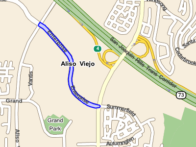
A street link GeoFence consists of the borders of the StreetLink, and can be used to test whether a vehicle (or any LatLon point) is inside (traveling on) the street link.
Related articles: Geofences Concept.