Map Styles and Parameters |
Learn more about Verizon Connect GeoBase.
Get information about the latest release
Map Styles take the abstract geometries and labels contained in a GBFS map data file, and turn these into attractive, readable maps. GeoBase provides fully featured built-in map styles for desktop use, and with Verizon Connect GeoBase WorkBench and the Chameleon language, you can develop your own map styles perfectly matched to your application and hardware capabilities.
Map Styles can be set using the MapStyle class. This class can be used to recall built-in styles, or create custom styles from .cam and .ecm files.
This tutorial demonstrates how to try out some example custom map styles in the Verizon Connect GeoBase Map Explorer sample application.
This tutorial explains how to create a basic map style using the Chameleon language in WorkBench.
This tutorial explains how to use map styles when using a JavaScript client with a GeoStream server.
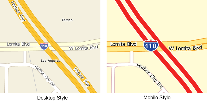
GeoBase provides two powerful built-in map styles; one designed for use on desktop or server class hardware, and a cut down style designed for use on resource limited hardware or for applications focused on Navigation.
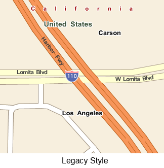
In addition to these styles, GeoBase also includes a legacy map style for desktop or server use, matching the map style used in releases prior to GeoBase 4.0. This map style is in maintenance mode, and will receive no futher updates.
If you want to use the legacy style for all IMap objects, without having to set the style on a per-map basis, then there are two options, depending on your data source:
|
The built-in map styles are accessible via the MapStyle class properties DefaultStyle, MobileStyle, and LegacyStyle respectively, and can be enabled for an IMap object by assigning them to the Style property.
/* Set map style to Mobile/Navigation Style and redraw */
mainMap.Style = MapStyle.MobileStyle;
mainMap.Invalidate();Parameters are variables, defined in a map style's Chameleon code, which can be set from within .NET code by using the MapStyleSetParameter method. This allows changes to be made to map rendering without having to edit the underlying style file.
mainMap.Style = MapStyle.DefaultStyle;
/* Enable "detailed" parameter for extra detail at distant zooms. */
mainMap.Style.SetParameter("detailed",true);
mainMap.Invalidate();
The following parameters are available in GeoBase's built-in map styles:
Parameter Name | Type | Available In | Notes |
|---|---|---|---|
detailed | boolean | Desktop, Legacy | Extra road detail will be drawn at distant zoom levels. This is enabled automatically when using a GeoStream server. |
Show_Point_Addresses | boolean | Desktop, Legacy | If a supplementary Point Address datafile is present, address numbers will be rendered on the map. |
Hide_Internal_Country_Borders | boolean | Desktop, Legacy | State/Province boundaries will no longer be drawn on the map. This can make it easier to distinguish national borders, particularly in areas with a large number of small countries, such as Eastern Europe. |
fastpanning | boolean | Desktop, Legacy | Increases map rendering speed during panning by ceasing to render some map elements, and decreasing the quality of others. |